GONCALO BORGES, PhD Student
URBAN STUDIES PROGRAMS AT THE UNIVERSITY OF WISCONSIN - MILWAUKEE
URBAN STUDIES PROGRAMS AT THE UNIVERSITY OF WISCONSIN - MILWAUKEE
INTRODUCTION
|
Washington Park: Green Boundaries and Social Action. The green because of the park, and because of its morphology. Social action because all the physical and metaphysical elements present in the current case are the product of human action. The space, the green, the boundaries, and the neighborhoods around Washington Park are socially constructed, and therefore are the product of social action. In simple words: We made it, we act over it, and we can change it.
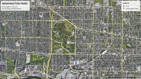
Washington Park – the actual park – is a 128.5-acre urban park in Milwaukee, Wisconsin. Its original name was West Park. This park is a Modern cultural landscape designed by Frederick Law Olmsted, and was built in 1891 in the peak of Milwaukee’s industrial and manufacturing era. In 1891, at the time of the park’s opening, that same space was a mixture of farmland and early suburbia. It was served by old plank roads that connected Milwaukee to the neighbor city of Wauwatosa. Later, around 1895, carriageways brought a higher flow, and in the early years of the 20th century, the street car transformed Washington Park into a major landmark, recreation destination, and a key cultural landscape of the industrial and Modern Milwaukee. The popularity of this location had also a very peculiar and special spice: Washington Park was also the original location of the city's zoo from 1892-1963. Therefore, Washington Park was famous for its animals, for the water, for the ever-rare urban greenery, for the 4.000 new trees, and for the ability to gather thousands of Milwaukeeans every week. Washington Park, designed by Olmstead, represented a new era. An era of broad vistas, progress and dominance, and represented the ultimate stage of the marriage of rationality with nature. |
|
As the 20th century marched, the park was influenced by all sorts of phenomena: two World Wars, anti-German sentiments (at the time the majority of Milwaukee’s population was ethnically German), and more importantly, the park was affected by the depression. Not even the animals were safe, some humans thought about slaughtering them as an austerity measure. The surroundings also changed. The neighborhoods around the park gained vitality, and became urban. More urban than ever, and increasingly connected to the center of the city. Washington Park – the neighborhood – and other neighborhoods north, east, and south of the park soon became desirable locations for middle and upper-class residents. However, the Great Depression came up no longer after the last houses went up around the park. And soon the other sides of the Modern and rational world crashed against that new era. Broad vistas were no longer that broad during the 1920s. As the Depression left, Washington Park regained forces, and in 1938, the remarkable band shell (a Milwaukee landmark) was inaugurated. It was called the Temple of Music, and it was built with a voluptuous donation from Emil Blatz: $100,000. The Temple of Music and its cost symbolized a second era for the park and for the neighborhood (Aderman, 1987; Gurda, 1999).
The band shell was successful space until the 1950s-1960s, the zoo was popular, and the park kept its cultural importance. But the Great Depression left its scars, and red lining was left in place. Therefore, in the second half of the 20th century, Washington Park changed again – and this time the space changed dramatically. Red lining started to create focuses of segregation after 1938. In the 1950s the Highway 41 was built, and in 1959 the street car line was extinct, which changed the space and many resident’s lives. The zoo left in 1963, and with it many businesses disappeared. And finally, Washington Park’s older and wealthier residents left to the suburbs for good. There was a white flight - that is the more objective description. During the 1970s, 1980s and 1990s, this area of the city, like many others in the north side, became the home of Milwaukee’s black residents, and the home of many immigrants. The third era of Washington Park is mostly characterized by segregation, by a sense of abandonment, but also by hope, and by resistance. The contemporary Washington Park and its surrounding neighborhoods are today a complex reality, where boundaries, segregation, resistance, culture and landscapes dance in a stage that is much bigger than the local band shell. Washington Park is complex, and represents one of the most complex and sensitive cases of Milwaukee, and American cities (Aderman, 1987; Gurda, 1999).
The band shell was successful space until the 1950s-1960s, the zoo was popular, and the park kept its cultural importance. But the Great Depression left its scars, and red lining was left in place. Therefore, in the second half of the 20th century, Washington Park changed again – and this time the space changed dramatically. Red lining started to create focuses of segregation after 1938. In the 1950s the Highway 41 was built, and in 1959 the street car line was extinct, which changed the space and many resident’s lives. The zoo left in 1963, and with it many businesses disappeared. And finally, Washington Park’s older and wealthier residents left to the suburbs for good. There was a white flight - that is the more objective description. During the 1970s, 1980s and 1990s, this area of the city, like many others in the north side, became the home of Milwaukee’s black residents, and the home of many immigrants. The third era of Washington Park is mostly characterized by segregation, by a sense of abandonment, but also by hope, and by resistance. The contemporary Washington Park and its surrounding neighborhoods are today a complex reality, where boundaries, segregation, resistance, culture and landscapes dance in a stage that is much bigger than the local band shell. Washington Park is complex, and represents one of the most complex and sensitive cases of Milwaukee, and American cities (Aderman, 1987; Gurda, 1999).
THE PROJECT
As seen, Washington Park is not mere case of green space and recreation. And this case is neither a simple tale of different neighborhoods and their urban transformation. Washington Park and its sphere of influence is a case of social action and spatial and cultural boundaries. The current project observes cultural landscapes. Hence, first let’s think about cultural landscapes before further developments.
As Sen and Schmitz (2015) showed us with their past field work at Washington Park, cultural landscapes are a phenomenon materialized in space. Cultural landscapes are the materialization of a complex relationship between individuals and their larger cultural and material contexts. According to the authors, such landscapes are not necessarily physical, tangible and visible – often may be symbolic, experiential and sensorial invisible to our eyes.
The other fundamental component of this project are the theories involving environmental justice, urban green spaces, race, class, and urban social action. Therefore, the current project is influenced by theories and previous researches that have studied how neoliberalism and lack of public investment have affected the relationship between people and green spaces, and how certain disregards have contributed to the urban decay (Perkins, 2009; Jennings et al, 2012). Although, the core of this project are previous theories and studies about a very concrete problem: how green spaces tend to create boundaries between communities, classes, and races (Solecki and Welch, 1995; Campbell, 1996; Gobster 1998; Heynen 2006; Byrne and Wolch, 2009; Byrne, 2012; Wolch et al, 2014).
Hence, is Washington Park physical and cultural boundary between races, communities and social classes? Are there any spaces within the park where such differences are left behind, and forces of resistance come to the surface?
The current project aims to understand how the park might produce green boundaries (or green walls) between people that live in the surrounding neighborhood. But, in the other hand, this project also aims to observe another relevant aspect of these green boundaries: how the park’s edges might create pools of resistance, or in other words, how certain parts of the park might produce points of encounter between communities, races and classes based in social action.
THE RACIAL DOT MAP:
WASHINGTON PARK AND SEGREGATION
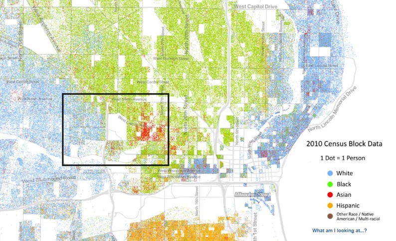
RACIAL DOT MAP. SOURCE: University of Virginia
The core of the project are maps, and the public history of the place. Maps besides being socially constructed items, are also great windows to understand boundaries, flows, and performances. The geographies shown by maps can build a very relevant narrative, and that is the challenge presented here.
In this map, we can observe the racial dot map of Milwaukee[1]. This map immediately shows the racial division surrounding the park and affecting the surrounding neighborhoods. The division is visible, and that division is a social process started in the 1930s. As it is possible to observe, the east side of the park is mostly black and Asian, and the west is mostly white. Hence, Washington park is in the epicenter of Milwaukee’s racial segregation problem. The park itself, in addition to the highway and other green and brown spaces are part of a larger segregation tendency and physical boundary that is visible between west and east in the north side of the city. Washington Park is not lonely in this segregation process, but it is indeed a major boundary. Again, as the map and the numbers show, Washington Park creates a green wall between minorities and mostly middle class white residents. Ideally, Washington Park should be a place of communion between residents and visitors, and it might be in its edges, however, as the Census show, that the park is a boundary between residents and lives, a green wall between races and ethnicities.
[1] https://demographics.virginia.edu/DotMap/index.html
THE RED LINE MAP
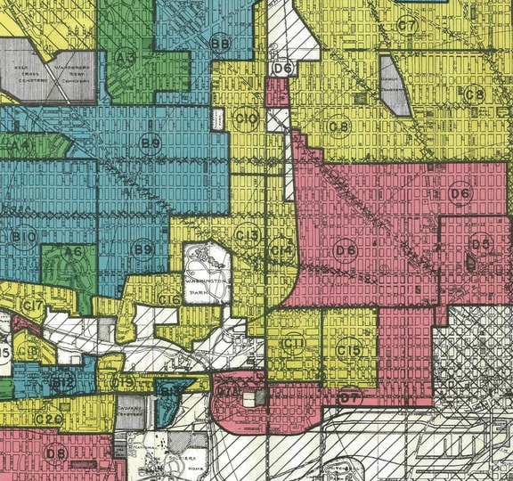
RESIDENTIAL SECURITY MAP, APRIL 1938 - HOME OWNERS LOAN CORPORATION. SOURCE: UW-Milwaukee Library
MAP LEGEND: Green – First Grade A; Blue – Second Grade B; Yellow – Third Grade C; Red – Fourth Grade D
MAP LEGEND: Green – First Grade A; Blue – Second Grade B; Yellow – Third Grade C; Red – Fourth Grade D
But where did this segregation come from? Besides the historical data mentioned in the initial paragraphs, the explanation can be back tracked to the Home Owners Loan Corporation actions, and its Residential Security Map or the Red Line map created in April of 1938 for Milwaukee. This map shows us one of the most relevant roots of the current problem, and also part of the historical process. This map tells a story, a story of white and capitalistic dominance. This map is an historical artifact itself. This map offers an important start for the question: how did Washington Park became a boundary, how did this place become so unequal or divided? Red Lining was, and is a major problem in Milwaukee.
If we overlay the Red Line map with the Racial Dot map it is possible to observe that such divisions were designed in 1938, and at the time, as today, the park itself was part of a buffering zone. Washington Park, both in the past and in the present, is part of the evidences and narratives surrounding such shameful Red Lining and divisions. When the old Zoo left in 1963, the Red Line was already there since 1938. Therefore, further flows, boundaries and performances were influenced by it.
If we overlay the Red Line map with the Racial Dot map it is possible to observe that such divisions were designed in 1938, and at the time, as today, the park itself was part of a buffering zone. Washington Park, both in the past and in the present, is part of the evidences and narratives surrounding such shameful Red Lining and divisions. When the old Zoo left in 1963, the Red Line was already there since 1938. Therefore, further flows, boundaries and performances were influenced by it.
TIME, PROCESS AND TRANSFORMATION
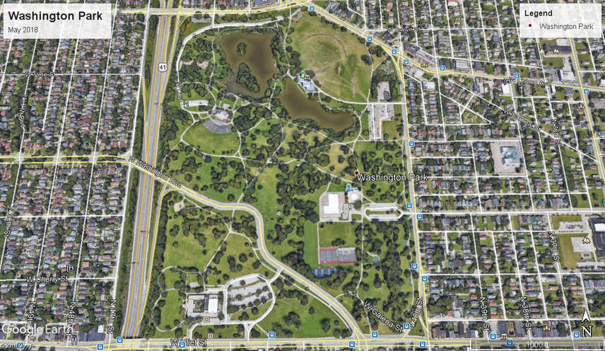
Spatial and physical changes are very important to understand Washington Park and the surrounding neighborhoods. In order to observe some general and relevant spatial changes, we can observe the aerial pictures made available by the Milwaukee County[1]. Here we can find evidences of changes that transformed the area into the contemporary reality. Here we have an aerial narrative between 1937 and 2015. In 1937, we can find a highly dense set of neighborhoods around the park; Vliet, Lisbon and North were the major arteries across the area, and the Zoo and the pond were the stars of the park. Some industrial development was already visible on the south side of the park. In 1963, we can see a major and structural transformation: the highway WI-175 or Stadium Highway. This major piece of transporation developed in the 1950s and 1960s as part of the highway system developed in the city, was a major spatial transformation, therefore reinforcing the boundaries between the west side of the park, and the east side of the park. Simultaneously, the park itself changed: the Temple of Music or Band Shell was already part of the landscape, and the Zoo is now absent. Across the 1960s, 1970s, 1980s and until the present the neighborhoods around the park suffered less major spatial transformations.
However, within the park boundaries, focuses of resistance, flow and performance were developed and produced a complex mixture of culture and space. Here it is possible to find evidences of changes that for sure had effect in the community: the Washington Park Senior Center replaced the Zoo; the ball park in the northeast side of the park and some soccer fields were improved (currently the ball park no longer exists and will be replaced by three soccer fields); a public pool was built(in the 1960s), as well as tennis courts and basketball courts. Currently, those basketball courts, the tennis courts, and the soccer fields represent important spaces of resistance and gathering. Those are core cultural spaces. Simultaneously, if we observe the northeast side of the pond, we will find the Urban Ecology Center. Built in 2007, the Urban Ecology Center is a major actor in the area while operating at the park, and from the park to the public institutions such as schools. Excellent gatherings, performances, flows, and resistance are often found here. At the center, those green walls, the boundaries, the shades and colors are dissipated, and at least for hours (every week), the red line goes away.
[1] http://county.milwaukee.gov/mclio/applications/interactivemapping.html
THE PARK, INEQUALITY, SEGREGATION AND BOUNDARIES
The following collection of maps was retrieved from two fundamental sources: the US Census Bureau[1], and the United States Department of Agriculture[2] . All the data corresponds to the year 2015, and is visible in census tracts (the closest to neighborhood level possible). Here we can overlay and continue our narrative. As it is visible, the areas east, south and north of Washington Park, predominantly black and Asian, are the areas with the lower household income, while the west side of the park (Washington Heights) are the areas with the higher household income (between $50.800 and $71.033 per year). Neighborhoods such as Washington Park, Martin Drive (south of the park), Metcalf and Sherman Park (north of the park) present us with households with income between 20.446 and 3030.563. These income differences are not independent from race, red lining, physical barriers, and socially constructed forms of separation.
In what concerns the unemployment rate, the west side of the park presents a much lower rate (between 1.8% and 6.9%). The other areas surrounding the park present much higher values, mostly range from 12.2% to 20%. This contrast between west and east of the park is shocking. Therefore, as a consequence of such inequalities and divisions, the residents on the east side of the park are the ones that more often are found in situations of poverty. As seen on the Census’ and on the Department of Agriculture maps, the east side of the park presents a reality where between 26.6% and 49.5% of the tracts residents are below the poverty line. The west side: the range moves between 3.8% and 15.2%.
[1] https://factfinder.census.gov/faces/nav/jsf/pages/index.xhtml
[2] https://www.ers.usda.gov/data-products/food-access-research-atlas/go-to-the-atlas/
Another aspect that we should overlay here, and therefore include in further critical thinking, is food security. According to the Department of Agriculture and the US Census, the differences between west and east are visible, therefore the same scheme of boundaries is followed here. And it is not coincidence, especially because racial segregation, unemployment, unequal income and poverty are often factors that lead people into food insecurity. When we observe the map retrieved from the Department of Agriculture, we can observe that the Washington Park neighborhood and the areas immediately south of the park are part of a larger food desert that has been affecting Milwaukee. Therefore, Washington Park neighborhood, Martin Drive and Walnut Hill are registered as low income tracts where a significant number of residents is more than ½ mile from the nearest supermarket. Such distance to supermarkets is thus bigger in the east, north and souh of Washington Park. The food desert ends basically after the park itself. The park itself seems to be a barrier as well – it increases the distance to access the supermarkets in the west side.
In what concerns food stamps, it is visible that the areas east of the park have higher percentages of population receiving food stamps. If we observe the map, we can visualize a clear “perceptual” boundary. On the east side of the park we find percentages ranging from 47.5% to 59.6% of population receiving food stamps. In the other hand, in the west the percentages are lower. Most of the west has percentages ranging from 10.3% and 35.0%.
In what concerns food stamps, it is visible that the areas east of the park have higher percentages of population receiving food stamps. If we observe the map, we can visualize a clear “perceptual” boundary. On the east side of the park we find percentages ranging from 47.5% to 59.6% of population receiving food stamps. In the other hand, in the west the percentages are lower. Most of the west has percentages ranging from 10.3% and 35.0%.
THE PARK, BOUNDARIES AND HOUSING
The following two maps show two fundamental problems concerning the areas surrounding Washington Park. The first map represents the eviction rate in the census tracts surrounding Washington Park. This map was retrieved from the Eviction Lab[1]. Once again, the division between west and east is visible. In the east the eviction rates are significantly higher. In the east the rate presents high values such as 11%, and ranges between 4% and 11%. In the west, the percentage of evictions is much lower – almost inexistent. In the west must tracts present less than 1% of evictions, or maybe 1%, or 1.5%. Evictions are more common in the east side of the park. The boundary is again clear, and if you are on the east, the menace of eviction is real, more common, it is part of many residents’ everyday life.
Another interesting evidence is the land value. According to the values listed on Zillow[2], homes in the east side of the park have a much lower value, than the homes in the west side of the park. Houses in the west side of the park have values around $100.000, $200.000, and sometimes higher. In the east, the values are lower, often we can find homes on sale for $10.000, $20.000, $40.000, $50.000. Besides the values dictated by the market, what we can observe is a division, a cultural and spatial division where the value and cultural meaning given to the spaces at west and at east are significantly different. Living on the east, owning land or an home on the east is completely different from living on the west, owning land or an home on the west. And the housing market is thus a result of such complex of divisions, spatial organization, and cultural phenomena. The east and its homes have less value. And if we follow the previous maps and the numbers, none of this is a surprise. There is a process, a social construction of boundaries, and division. And the housing market, like any other market, is a set of rules made by humans, and whatever actions made are the result of social action.
[1] https://evictionlab.org/map
[2] https://www.zillow.com/
RESISTANCE FOCUSES, SPACES OF PERFORMANCE AND FLOW
As previously seen, the Washington Park’s narrative shows the emergence of difference, of division and segregation. We can observe the emergence of boundaries, and how the park is used as a green boundary, and how the park is part of a larger system of exclusion and segregation that divides Milwaukee. Such boundaries and divisions are physical, but more importantly, they are social and cultural. Therefore, the green space might be a buffering zone, a physical (long and wide) barrier, but the core of the problem is how social action and culture are the key items that divide, and transform and use the space (the green too) in manner that divides, segregates and establish boundaries between communities.
However, Washington Park provides the other side of the coin. This narrative is also about resistance. This narrative is about performances and flows that surpass the boundaries and the divisions. And such resistance, performances and flows are also socially constructed. Such focuses of resistance, performances and flow are cultural forms that happen at the Washington Park. Such complexity happens at this cultural landscape, and it is a fascinating to observe how the green wall it is also a green stage for resistance, performances and flows that break the boundaries.
However, Washington Park provides the other side of the coin. This narrative is also about resistance. This narrative is about performances and flows that surpass the boundaries and the divisions. And such resistance, performances and flows are also socially constructed. Such focuses of resistance, performances and flow are cultural forms that happen at the Washington Park. Such complexity happens at this cultural landscape, and it is a fascinating to observe how the green wall it is also a green stage for resistance, performances and flows that break the boundaries.
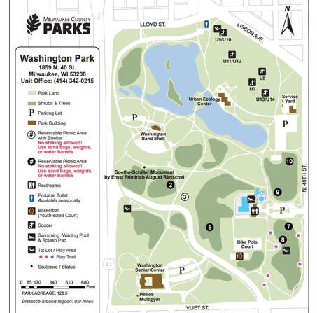
Where are those focuses of resistance, and spaces of performance and flow located? Based on content analysis and field observation, such spaces are mostly found in the edges of the park, but not exclusively. One of the most relevant spaces of resistance is the Urban Ecology Center at the Washington Park[1]. Opened in 2007, this branch of the Urban Ecology Center is known for several community based initiatives, such as serving the area’s schools with their acclaimed Neighborhood Environmental Education Project. Besides several after school programs, this branch offers other meaningful services and events to the community – from health consultation, biology and geography based workshops, and even kayaks and canoes for renting. However, a significant face of the Urban Ecology Center is its connection to the children that live in all the neighborhoods around the park. During many hours per week, children from all the four corners, from different neighborhoods, classes, races and ethnicities gather around the center. The boundaries are gone.
[1] https://urbanecologycenter.org/our-branches/washington-park-unique-features.html
[1] https://urbanecologycenter.org/our-branches/washington-park-unique-features.html

Other spaces of resistance are the basketball courts, the bike polo court, and the soccer fields. The ball park no longer exists. In these spaces, especially during the Summer, children, teenagers, adults, and families gather here to establish fluid and highly dynamic performances around the cultural meanings of sport and physical activity. Most people come from the surrounding neighborhoods, and thus, the flow and performances around basketball, soccer, and bike polo are a mixture, a complex social and cultural tissue, that again tend to suppress the boundaries. For the most part, these spaces make the boundaries go away, the goal is the performance, and such performance tends to deny structural boundaries.
The Washington Band Shell (former Temple of Music) is another important space of resistance. Here, across the late Spring, Summer and early Fall, music show, festivals and other gatherings are common place. In this edge of the park, the cultural meanings and dynamic are shared, produced and reproduced. Again, the audience is diverse. The performances in the stage and off the stage are equally diverse too. The band shell, besides being a landmark of the city, it is a common ground for many residents to gather and share cultural items. Here, we find a pure cultural landscape in the sense that the actual space, its design and purpose, as well as the performances are strictly cultural. And here, in such a cultural landscape, we find elements that are not simply physical, but sensorial, metaphysical. Therefore, the band shell and its events are spaces of complex exchange and performances. A permanent flow, we could say. Again, at this place, often the boundaries are gone. The music, the performances, and exchange, does not claim the division. Instead, it requires connection.
Outside of these main spaces and focuses of resistance, at the park we can find play areas for children, where often boundaries are suppressed as well, and we can find a public pool (in the east section of the park). The public pool is also an extremely relevant space of resistance and performance. It is used by thousands of residents during the Summer, and offers an ever-exciting force to park and to the surrounding communities.
CONCLUSIONS
|
(1) Washington Park (the park), and the whole area surrounding the park, including the several and distinct neighborhoods, is the result of a process that has lasted approximately 150 years. However, most of what we can observe today is traceable to the year 1938, and it is the result of social constructions that allowed divisions and exclusions, and also the result of forms of governance that were not able to permanently reduce or extinct boundaries between communities, races and classes. The contemporary neoliberal city of Milwaukee is a divided space, and Washington Park is an evidence.
(2) As we can see across the maps and data, Washington Park is indeed a green boundary (or a wall like several authors might call it). Therefore, the green space operates as a buffering zone, and as a physical (wide and long) boundary between communities. This boundary establishes a more or less fluid west and east division. The park is also a barrier for those who live in the east side, especially in what concerns the access to food, or other fundamental life elements. (3) Washington Park is part of a larger system of segregation and boundaries between different communities, neighborhoods and sections of the city. This park is just another brick in the wall. (4) The park is a boundary, and it is a socially constructed boundary. From the physical aspects, to the cultural aspects, the contemporary park is a result of social action and of an historical process. If the park separates communities, such separations are the product of social and historical forces. Although, the park is also a space of resistance. At the same time as Washington Park is a boundary, this park is also a space of resistance, performances and flows that gather different people from different neighborhoods. Thus, while being a clear boundary, the park is simultaneously a complex space of resistance where such boundaries are lift, forgotten, and suppressed, and where people gather in performances and flows that resist to the social and green boundaries. (5) Washington Park is one of Milwaukee's prime cases, and one of the more complex cultural landscapes. An evidence of such complexity is its historical and social process, and how a singular space can simultaneously be a boundary, but also a space of resistance. Washington Park also holds the potential to be the birthplace of a larger change in the city of Milwaukee. |
REFERENCES
|
