Highway construction and urban change in the 20th century
Historical aerial photographs from 1937 to 1995 in the slideshow below illustrate how the construction of highways in the 1960s, like Interstate 94, transformed the urban landscape of Milwaukee.[1] During this decade of fast-paced highway construction, over 6,000 homes were destroyed and countless more were displaced.[2] In addition to acting as a defense strategy in case of nuclear attack, President Dwight D. Eisenhower justified this construction through the 1956 Interstate Highway Program as a means of improving safety, congestion, and the economy.[3] However, other visuals like Milwaukee’s 2010 racial dot density map and 1938 residential security map prompt the question: improved safety, congestion and economy for whom?
Redlining and highways as racial boundaries in Milwaukee
Historically, highway projects across the United States have bisected predominantly African American and low-income neighborhoods resulting in the displacement of both residents and businesses.[4] Milwaukee has been no exception. The 1938 redlining map of Milwaukee County illustrates the ways in which the Home Owner’s Loan Corporation, along with real estate interests, developers, and mortgage lenders, defined the worthiness of neighborhoods according to the environmental risks and racial groups living there.[5] Areas marked as green were the “best,” areas in blue were “still desirable,” areas in yellow were marked as “definitely declining” and areas in red were marked as “hazardous,” hence the name “redlining.” These structural discriminatory practices were instrumental in establishing the racial hyper-segregation characteristic of Milwaukee County today. For example, by comparing Milwaukee’s 1938 redlining map (below, right) with the 2010 racial dot density map (below, left) it becomes evident how built infrastructure like highways further fortify existing segregated landscapes. Here, the I-94 corridor acts as a racial boundary separating the city’s predominantly African American north-side (represented in green) and Hispanic south-side (represented in orange), once marked as red, hazardous neighborhoods. At the same time, the corridor facilitates the flow and movement of people and goods from the white suburbs to downtown (represented in blue).
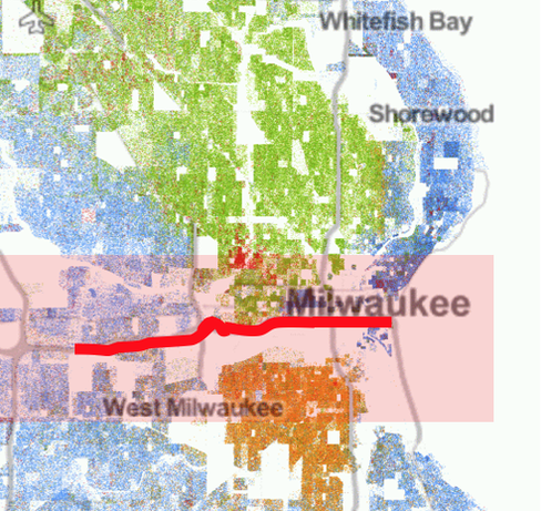
Milwaukee Racial Dot Map, 2010; Image Credits: University of Virginia, Weldon Cooper Center for Public Service
|
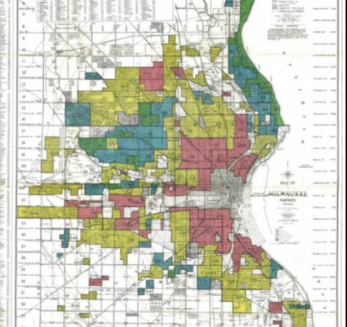
Map of Milwaukee County, Wisconsin: residential security map 1938
|
Highway expansion projects & contemporary racial disparitiesEven though the practice of redlining became illegal with the passage of the Civil Rights Act in 1964, its history has left an imprint on the landscape of many U.S. cities, including Milwaukee.[6] Whereas highways enabled “white flight” to the suburbs in the 1950s and growing attention to regional transportation, the transit needs of urban marginalized populations were neglected.[7] In other words, less mobility for urban, low-income, communities of color correlates to less access to employment and other basic services. In a more subtle way, contemporary highway expansion projects that fail to implement public transit for city residents further compound regional segregation.[8] As a result, overt discriminatory practices such as redlining have shifted to more covert forms of discrimination such as state investment in highway expansion projects at the expense of public transit. This shift further reveals how highways are far from being neutral infrastructure, but the result of stakeholder interactions at varying levels.[9]
|
Interview on highways & racial segregation in MilwaukeeUWM Geography and Urban Studies Professor Anne Bonds discusses the relationships between racial segregation, mobility, highways, and what they mean for highway expansion projects today.
Photo: I-94 Expressway, east from the 27th Street Viaduct
Source: Mayer, 1974 |
References:
[1]Bessert, C. (2016). Wisconsin’s Interstates. In Wisconsin Highways: Highways and byways of the badger state. Accessed May 20, 2018. Retrieved from: http://www.wisconsinhighways.org/interstates.html
[2]OnMilwaukee (2011). Milwaukee’s freeway history. Retrieved from: https://onmilwaukee.com/buzz/articles/milwaukeefreewayhistory.html?viewall=1
[3]Weingroff, R.F. (2017). Original Intent: Purpose of the Interstate System 1954-1956. In U.S. Department of Transportation Federal Highway Administration. Retrieved from: https://www.fhwa.dot.gov/infrastructure/originalintent.cfm
[4]Karner, A, Golub, A., Martens, K., & Robinson, G. (2017). Transportation and environmental justice: History and emerging practice. In R. Holifield, J. Chakraborty & G. Walker (Eds.), The Routledge handbook of environmental justice (pp. 400-411). Routledge.
[5]Nelson, R.K., Winling, L., Marciano, R., Connolly N., et al., Mapping Inequality, American Panorama, ed. Robert K. Nelson and Edward L. Ayers, accessed May 20, 2018, https://dsl.richmond.edu/panorama/redlining/#loc=5/40.430/-88.286&opacity=0.8&text=intro.
[6]Golub, A. (2014). Moving beyond Fordism “Complete Streets” and the changing political economy of urban transportation. In S. Zavestoski & J. Agyeman (Eds.) (2014)., Incomplete streets: Processes, practices, and
possibilities(pp. 36-53). Routledge.
[7]Golub, A., Marcantonio, R. A., & Sanchez, T. W. (2013). Race, space, and struggles for mobility: Transportation impacts on African Americans in Oakland and the East Bay. Urban Geography, 34(5), 699-728.
[8]NAACP v. Ross, 2:17-cv-00297 (2017).
[9]Bullard, R. D., Johnson, G. S., & Torres, A. O. (Eds.). (2004). Highway robbery: Transportation racism & new routes to equity. South End Press.
Other sources:
- Header photo: Milwaukee County Land Information Office. 1967 Aerial Photo [raster dataset]. Milwaukee, WI. 2018
- Bonds, A. (2018, May 4). Personal interview.
- Soundcloud photo: Mayer, H. (1974). I-94 Expressway, east from the 27th Street Viaduct [Photograph]. Retrieved from: http://collections.lib.uwm.edu/digital/collection/mkenh/id/155/rec/8
